Flood Risk ManagementRemote Sensing and Artificial Intelligence for Wildlife Conservation
Remote Sensing
Satellite, aerial and UAV remote sensing technology can support scientists and conservationists to identify, track, monitor, and access wildlife in the most remote areas around the world, including marine habitats. Satellite remote sensing technology has benefited wildlife conservation efforts by utilizing these technologies to protect National Parks and aid in improving the way endangered wildlife are being monitored in their natural environments. Satellite imagery, GPS, and GIS technologies offer advantages to see what is happening on the ground and in wildlife habitats by using temporal comparisons of multispectral satellite imagery and GIS data to detect wildlife habitats in need of protection and conservation. Multispectral satellite imagery produced from satellite sensors such as the WorldView-3 can provide 30cm panchromatic, 1.20-meter 8-band multispectral, and 3.7-m short wave infrared (SWIR) resolution to help detect sensitive areas with precise details.
WorldView-3 Satellite Image (30cm)
Wildlife Monitoring, Caribou Herd Migration – North Slope of Alaska
Click the image to view the animation.

Copyright © MAXAR/Processed by Satellite Imaging Corporation. All rights reserved.
Satellite images allow scientists and conservationists to estimate patterns and rates of deforestation in and around protected areas using multispectral band combinations to produce satellite maps for the various vegetation indices. Vegetation indices such as Normalized Difference Vegetation Index (NDVI), SAVI, RESAVI, and green vegetation index maps are detailed images that give an absolute measure of the amount of vegetation present in wildlife habitats. These maps show the integrated result of environmental, physical, and natural factors affecting wildlife habitats. With calibrated data, you can routinely and quantitatively assess species count, status, and variation across habitats.
Satellite images, GIS, and global positioning systems (GPS) are being deployed to collect data for integration, analysis, modeling, and satellite map production for wildlife migration, habitat mapping, and conservation activities. With the use of GPS tracking collars and camera traps, wildlife researchers, and conservationists can collect baseline data, daily movements, and behavioral data that can provide critical information on the location of species by satellite, aerial, or UAV imagery.
Satellite sensors have been used for wildlife and marine surveys by detecting changes related to habitat including fecal count, removal of food, burrow mounts, and habitat destruction. Worldview-3 and Pleaides Neo with resolutions of 30cm can provide panchromatic and 1.2m 8 or 6 bands multispectral satellite imagery to support wildlife conservation and collect accurate and precise data of many endangered species.
WorldView-2 2m 8-Band Multispectral Satellite Imagery
United Arab Emirates – Wildlife Conservation – Marine Habitat – Dugong Detection and Identification
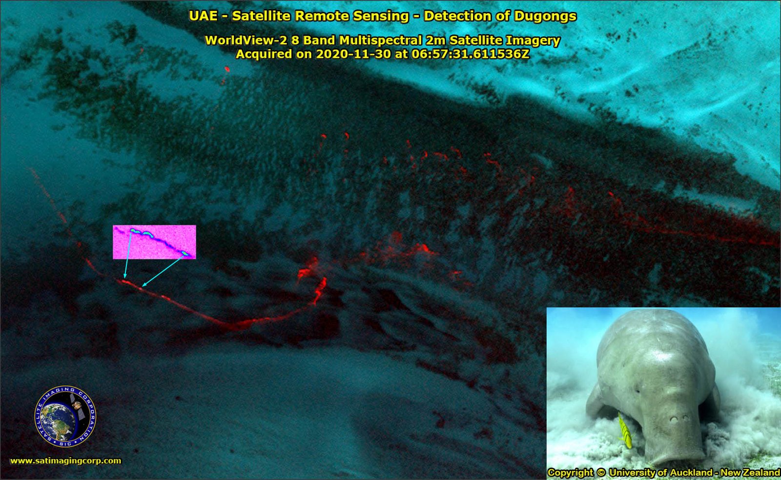
Copyright © MAXAR/Processed by Satellite Imaging Corporation. All rights reserved
Artificial Intelligence (AI) and Machine Learning (ML)
The latest innovation to aid in protecting and conserving the national parks has been from the utilization of Artificial Intelligence (AI), Machine Learning (ML), and Computer Vision (CV) for wildlife conservation. AI for wildlife conservation takes advantage of Machine Learning and Computer Vision models. Using imagery collected by satellites or unmanned aerial vehicles (UAV) can predict behavior and provide near real-time reports of repetitive attacks by poachers that will assist anti-poaching teams in catching the offenders. This state-of-the-art technology enables scientists and conservationists to decrease illegal activities such as attacks on wildlife and natural resources.
AI applications are a great alternative to manual data collection, camera-trap imagery, or recording audio that can lead to days or even months of exhausting work. Using browser-based tools, programming libraries, and neural networks, AI augments conservation efforts by helping scientists and conservationists to detect and monitor wildlife by using satellite images and data to help identify a particular species that can be closely monitored to help protect the fauna and flora in national parks worldwide.
Species are critically declining and facing extinction due to agriculture, climate change, construction, wildfires, droughts, exploitation, and exotic collections. Habitats from forests to our oceans, grasslands,deserts, and wetlands are experiencing decay, and destruction from human activity, and climate change. With the technology of satellite remote sensing, GPS, GIS, and unnmaned aerial vehicles (UAV) researchers and conservationists have the capability to monitor and manage wildlife and their habitats to support conservation.
Wildlife Conservation Presentation
Click to view the presentation
Copyright © MAXAR/Processed by Satellite Imaging Corporation. All rights reserved


